Thursday 30 April 2009

Shropshire and into Cheshire - near dog experience..

Before leaving Leominster in the rain I said my farewells to the lovely Debbie (YHA Manager) and 'Land's End 30 miles a day' Chris, although I'll probably see him at John O'Groats! (Chris was later seen at Fort William - well done mate!)

I always knew that an Englishman's home is his castle but I had no idea I had my very own castle and village. I do wonder if the omission of the apostrophie is significant?
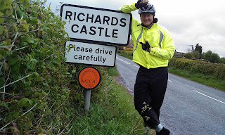

One of the redeeming features of this morning's rain (O.K. Only redeeming feature), was the constant tailwind. I felt sorry for Yaniv cycling 100 miles a day south from Edinburgh - he'd been knocked off his bike yesterday and the offernding driver had brought him to the YHA.

Passed Ludlow and brought a paper. By the time I'd reached Wenlock Edge for an early lunch the rain started to subside and it had stopped when I re-crossed the River Severn near The Wrekin hill.

I soon encountered my first real 'Near Dog Experience' as I came around a corner the pooch was right in my path on a wet muddy road - lived to tell the tale- dog is also fine as I missed it.

So good to beat the black clouds to Peter and Julie's house just in time or a meal. Their guide dog puppy Arthur still lets off some hideous odours.

Good to be in a bed again.-

For those of you who want to vote on my route Options - dream on - it is hard enough doing the planned route let alone looking at options. As I have planned to avoid A roads I spend a lot of time on very minor roads and I have been 'off-road' almost every day. The GPS (Satmap) is totally invaluable and my Trek mountain bike with road tyres is a good compromise - you couldn't do this route on a road bike. If anyone does want to cycle with me for a bit then use the maps to workout where I'll be, I generally leave by 8.30 at an average speed (includng stops of 9mph)

Stats. Distance 76.1 miles, max 32.6 mph. .Moving time 6:13 mps. With a total of 4655 feet climbed

GPSed Track "Leominster to Acton"


View my new track "Leominster to Acton" started in United Kingdom, England, Hereford.

Powered by GPSed.com - Free Mobile GPS Tracking Service


Up the Wye Valley

Wonderful night's sleep and porrage with syrup for brekie. As my emergency MP3 player did not arrive in yesterday's post I decided to hang on for it otherwise I could see it following me north but never catching me. Adele makes wonderful packed lunches.

The towers of the old Severn Bridge had been visible since yesterday, but close up it was huge. I met Steve Rogers who keep it in perfect nick and standing in the middle span I could feel it shake with every car and lorry.


Eventually I found a Welcome To Wales sign near Chepstow and headed off on the Welsh side of the Wye.

Passed Tintern Abbey and onto an old rail line to Symond's Yat,- passing a much smaller but equally bouncy suspension bridge

Steve (a local cyclist) gave me some sound advice about roads round Hereford and I set off passing the old covered market in Ross-on-Wye.

Quick photo stop in Hereford Cathedral, I resisted the temptation to visit the Mappa Mundi (old map, not an Indian restraunt).

As I climbed the last big hill I saw the back of the Malvern Hills, I can see the front of them from home, so I reckon this is as close to home as I get.

Leominster is preparing for its May fayre so the town was full of rides.

At the YHA I was welcomed by Chris who I had met last week at Land's End. As he was doing 30 miles a day I couldn't work out the tortoise had beaten the hare here. He confessed that he'd got a lift to Cheddar - it had taken me 3 days to cycle this!

More cycling tomorrow. . Stats for the day, 67.4 miles,climbed 5,068 feet, cycled for 5:46 hours,max speed 37.4 mph (weeeee...) average speed 11.7 mph - told you it was a good day. Weather perfect, SW good wind, dry and SUNNY. .

Wednesday 29 April 2009

GPSed Track "Alveston to Leominster"


View my new track "Alveston to Leominster" started in United Kingdom, England, Bristol.

Powered by GPSed.com - Free Mobile GPS Tracking Service


Tuesday 28 April 2009

Extra Day 6 pickies - can you see Rough and Tumble

Its is a VERY long way down...

Day 6 - The Moore I see you....

Hearty breckie at the Admiral's Rest and headed onto The Somerset Levels - and they were. Glastonbury Tor was just visible as I headed into Cheddar, as was my mast from my 'old job'.

Couldn't go to Cheddar without getting a local cheddar and English tomato granary roll from Highnam's Dairy (highly recommended). Elma Floyd, respendent in mop cap was a real star and also donated £5 to the cause - 'The Kindness of Strangers.....'

With roll packed in the luggage it was sufficient incentive to climb the 900+ feet up/through Cheddar Gorge before stopping at the very top. Although long it wasn't as steep as I'd feared and anyway after 6 days 'I do hills'.

It was a classic lunch in a classic location - mendip limestone wall, stile to sit on, electric fence behind me.

Still no 'Welcome to Somerset' sign but my right foot is on Somerset tarmac and my left in Avon or Unitary Authority of Bristol or Bristol City or something equally bland.

I couldn't resist re-routing my journey across Clifton Bridge. I have never seen so many inept 'toll money throwers' in my life, whilst I was there no less than 10 drivers (25%) either missed or had to reverse as they didn't have 50p. Aparently before the barriers were installed it was two different prices, more if you wanted a ticket - looks like this fiddle has been around as long as Brunel.

Delighted to struggle up my last hill and get to Pete and Adele Moore's and the most wonderful fish mornay prepared 'without the use of a safety net' or was that a recipie by Tim. Washing in the machine, bike cleaned and oiled, Guinea Pigs happy, out the bath and cold beer in hand. Life is good.

Statsfor the day, Mileage 57.6, average speed 9.9mph, max speed 30mph, climbed 4573 feet.

GPSed Track "Bridgewater to Alveston"


View my new track "Bridgewater to Alveston" started in United Kingdom, England, Bridgwater.

Powered by GPSed.com - Free Mobile GPS Tracking Service


Monday 27 April 2009

Slept well until the rain woke me up at 5a.m. It was still raining at 7a.m., only harder - if I stay at a hostel on the edge of Dartmoor I shouldn't be too surprised. I also need to confess I stole some Rice Krispies - they were in a ice-cream tub with a girl's name on it near the 'spare food' pile. It was only when the Warden said a lady was booked in for 4 nights that the penny dropped - if you are the Warden (or the lady with only 3 breakfasts) reading this, SORRY.

Having brought 20kg of kit I am determined to use it. Yesterday I tucked my 'waterproof' overtrousers into my 'wet suit' cycling over-shoes, to stop them catching the chain. The problem was that all the trouser run-off went straight into my shoes, today I sealed the trousers with Duck Tape - it worked a treat and for the next 3 hours the heavy rain was not channelled into my shoes. Result.

Turning off the old A30 I headed for Crediton, you could tell it was Devon as the rivers down the side of the road were red.

I avoided the long and pointless climb to Crediton but decided to play with my useless back brake at the station - what a superb surprise to find a real old-fashioned buffet - time for coffee and a bacon sandwich.

When I reappeared the rain had stopped and it was sunny, I donned shorts CORD T-shirt and customised hi-vis vest and headed off. Tiverton came and went and I joined the Grand Western Canal and flew along, missing a turn-off so making a very tedious 1 mile in the wrong direction (see the accompanying plot), it was only the headwind (still a westerly) that alerted me to my mistake.

With my back brake still not really working I Googled 'bike shops Taunton' to find the Bicycle Chain in Chip Lane had the necessary part, only 16 miles away. Off I pedalled.

In it's heyday this striking canal reached Taunton but today it ends at a tunnel, my GPS (co-pilot) was a giveaway as there was a VERY large hill ahead. At least the sun was still out and newly drenched Devon countryside was stunning.

-

Sneeked into Someset on a road with no sign, must get a photo on the way out.

Phone battery ran out, hence the jump in the track, texted Logistical Support (wonderful Chris) to send spare MP3 player to Bristol, so I can load music on that and solely use phone for photos, txts, track uploads and internet - how did Shackelton manage?

At Nynehead some locals had been exeedingly busy digging a huge vertical sided cutting through the Old Red Sandstone.

Bicycle Chain had the parts and I used 2 more items from my 20kg of luggage (leatherman and alum keys).

The Bridewater and Taunton Canal did what it said on the tin and in the afternoon sunshine I chased my lengthening shadow whilst trains to Penzance raced past.

The Admiral's Rest (not sure which one) B&B was well equiped for cyclists, I washed off the Trek and gave it a liberal lubrication before I did likewise in a bath and the pub. Funny town Bridgewater but has all the essentials I need. I'm sure the two old guys on my right are Archers extras - background noise in the Bull.

So another day over, in total 21.4, 43.2, 63.4, 66.4 and a whopping 80.6 today, so that makes it 274 miles so far, not bad really.

21.50, off to bed..

Oh by the way I have over 40 regular followers, including Finland and South Africa - you know who you are...

Daily Stats
80.6 miles, 7:17 moving, max speed 27.7 mph, avg speed 11.9 mph, height climbed 5,715 ft

GPSed Track "Oakhampton to Bridgewater"


View my new track "Oakhampton to Bridgewater" started in United Kingdom, England, Okehampton.

Powered by GPSed.com - Free Mobile GPS Tracking Service


Sunday 26 April 2009

The wind has shifted - long climbs, heavy rain - a long day

No fire alarms last night, but I was woken up by someone in the dorm sneezing - somewhat concerned to find it was me who seems to have contracted pig-flu. It will take my mind off my knee. Slightly unimpressed at the effectiveness of the 'drying room' - nothing was dry so I packed the clothes in the bottom of my bulging pannier and was thankful I brought 2 sets with me.


After my Wadebridge pasty the Camel Trail climbed through an idylic wooded valley culminating in a silver fish and a VERY long climb onto Bodmin Moor.


Fortunately it didn't rain until I neared the top and found some ponies, but for the next 3 hours I put on and off my waterproofs numerous times.


Although the Camel Trail was splendid the wet gravel did nothing to up my average speed, by 11:30 I'd pedalled under 20 miles - too slow. At that rate I'd miss the ferry to Mull on day 15, need to do 60 miles by 3:30 - UM!

Eventually rolled into an exceedingly damp Launceston and officially exited Cornwall and entered Devon by crossing the Tamar at Poison Bridge.


The old A30 towards Oakhampton was a relief after those Cornish lanes, wide with relatively gentle gradients. The YHA at Oakhampton is the old railway engine shed and is way above town so I climbed onto the 'Granite Way' and pedaled the last 6 miles on the old track which included two wonderfull viaducts.

Pleased to report that I have my own room tonight, the drying room is hot and the coffee is free - just 2 guests in tonight.

Strangers have been very supportive, at least 3 have donated - the latested being Pasty Shop Mike - thanks.

Now 10pm so I'm off to bed.

66.4 miles, max speed 31.1 mph, height climbed 9,143 feet, avg speed 9.6mph, time moving 6:57.

GPSed Track "Treyarnon to Oakhampton"


View my new track "Treyarnon to Oakhampton" started in United Kingdom, England, Newquay.

Powered by GPSed.com - Free Mobile GPS Tracking Service


GPSed Track "Treyarnon to Oakhampton"


View my new track "Treyarnon to Oakhampton" started in United Kingdom, England, Newquay.

Powered by GPSed.com - Free Mobile GPS Tracking Service


The sun is out - Sunday morning

Of to Oakhampton via wonderful beaches and The Camel Trail, just had a pasty in Wadebride - must dash 53 more miles today.

Saturday 25 April 2009

The wind is definitely a Westerly - you can see by the way the rain falls!

It rained last night, it rained hard, it rained so hard it came through the roof of the Youth Hostel and onto the bunk above mine. It also got into the fire alarm - which went off - twice 12 and 3 a.m. NOT impressed! Anyway by 7 the worst of the storm had passed Land's End by 9 am and I set off resplendant in my waterproofs.

As I pedalled along the road to Zennor it was literally awash with stones, rocks, mud, tarmac - but too wet and cold for a photo. Came across the whole of Cornwall's emergency services (Fire, Police, Ambulance and Coastguard - 22 vehicles) where a car had been washed off the road with tragic results.

I had decided to have a ham roll in Hayle, but could not resist the 'World Famous Pasty Shop' and the pasty was the best I've tasted.

Cycling to Portreath I played 'catch-up' with a father and son going End-to-End, eventually caught them at Porthreath when I paused for another picie.

Up the old tramway to Scorrier and lunched at an old mine - very windy. The route to Treyarnon included what Cornwall is famous for - steep, long hills. The only plus point was that the wind was definitely assisting me. The last 2 miles into Treyarnon was into the wind - I'm pleased I'm doing LEJOG not JOGLE (think about it).

As the YH had a drying room I shared my shower with some wet sweaty cycling clothes, hope they dry by the morning!

After a very passable bacon and pasta concoction (all my own work) I ventured out for the obligitory beach photo and retired to a very pleasant YH bar to write this Blog. Hope the roof does not leak tonight.

Knee update - still on the Ibubrufen and it is holding up.

Vital stats 63.4 miles 5813 feet climbed max speed 29.5 mph (scary) and I pedalled for 5:06 hours.